With the end of April comes the end of the school year. Over the year I have explored every part of the border, traveled into Mexico and hiked throughout Arizona. Now with summer coming on strong you can follow my new blog Lifeguard4Life Its focus is on lifeguarding through the summer and anything to do with the beach. There is also a live surf report.
My favorite part of the year was hiking in the border area. The desert is harsh and unforgiving. If you turn your back on it even for a moment, it will take from you. Deadly animals, painful plants, dangerous drug traffickers and a killer sun, the desert has them all. Hundreds of people have been killed crossing the border. Being in the same environment and experiencing the same hike is exciting and humbling.
Tucson has a lot to offer to the outdoors. Its weather, and geography is unmatched for desert lovers like myself. The city has so much to offer, the outdoor enthusiast can get lost for years in Tucson's wilderness; never crossing the same path twice.
This will be my last blog post for the school year. I hope that you enjoyed what I had to offer and hopefully I gave you some ideas of places to go yourself.

Friday, April 22, 2011
Monday, April 18, 2011
Magdalena, Sonora Mexico
 |
| Photo by Samantha Sais |
Located on a narrow street corner in Magdalena, Sonora, a saddle maker tinkers away at leather strips inside the small shop with mexican music playing over the am fm radio in the corner. The end result forming a lavish saddle ready for hard riding.
The store started when David Molina's father started making saddles in the 40s. Since then, the Molina family has been making saddles for every rider. From the serious rancher, to rodeo cowboys.
The saddles take 8 days from start to finish to complete. The majority of them are made from cow hide, but Molina's shop has made them out of everything from shark skin to ostrich hide.
People come from all over the world to buy a saddle from David Molina. For five thousand dollars you can own your own custom saddle that is shaped to you and your horse.
Saturday, April 9, 2011
St. Andrews
 |
A doctor and med-students go over a patients file at St. Andrews Photo by David McErlean |
This Thursday was the monthly children's health clinic in Nogalas Ariz. The clinic is put on by Saint Andrews church to help the poorer family's of Mexico that are not able to to pay for it themselves. Children from all of Sonora come to the clinic every month to receive a range of health care.
For this month, the clinic invited BorderBeat.net to come and observe the doctors and administrators that volunteers in action.
There was no better feeling than to witness a 5-year-old smiling as they see for the first time after getting their first pair of glasses, or hear for the first time after putting their first pair of hearing aids in.
Each child is given a fluoride treatment. The water in Mexico is not treated with fluoride. Without the fluoride in the water like here in the U.S. people tend to have more dental problems.

After the dental treatments, each patient is taken to the special area that they need and treated. While being treated, parents are given clothes and other necessary items that they will need when returning home.

The clinic sees and treats over 200 kids, new born to 18 years-old, from Mexico.
Tuesday, March 29, 2011
Photographing the Border
 |
| Me photographing water coursed in Southern Arizona Photo by Karl W Hoffman |
After going on a photo project with Karl W Hoffman with Skull Creek Media, I was able to get some photos of myself reporting.
Karl is a photojournalist who has lived on the border for the last 6 years, photographing and documenting the activities there.
 |
| Me photographing water sources in Southern Arizona Photo by Karl W Hoffman |
Saturday, March 26, 2011
Beer Mile
 |
| Tucson Unofficial Beer Mile Friday March 25, 2011 |
Last night at an undisclosed track in Tucson, different sports teams from the area competed in the annual secret event of the Beer Mile. The time was set beforehand. Waiting for a text message 30 minutes before the race, those entered in the race waited by their phones with fellow teammates to receive the location.
With the location set, racers get to the track and set up their transition areas, placing their beers in a line at an easy to reach spot on the track.
Dressed in costumes to intimidate the other competitors, 20 athletes stand at the starting line, armed with 3 beers at their feet while holding one steadily in their hand. Fingers idly wait on the pop top, just waiting to pull the trigger and start the race.
The official timer counts down. Three. Two. One. GO!
The sound of 20 cans opening together fills the air, then silence as the athletes begin to chug. Seconds pass and the first racers are off. With a toss of their empty can, they sprint into gear and charge around the dark track with something to prove.
Coming back into the transition area, the first racers reach for their second beer. Starting to feel the effects, some racers stall drinking so they don't lose it; avoiding the end penalty lap. The leaders are still looking at record setting pace.
As the third lap comes, racers start quickly adding penalty laps. Laying on the grass, the race track becomes for only the serious racers.
A triathlete finishes his last beer and run his last lap. In a full dead sprint, he is set to win by a long shot as long as he can keep it together. He crosses the finish line with an official time of 7:04. Second fastest time in Tucson according to the Beermile.com records book.
It was a challenging event with no right way to train for it. Look out for next years official Tucson Beer Mile charity fund raiser.
All competitors were 21 years old or older. Please drink responsibly. Always use a designated driver.
Tuesday, March 22, 2011
First Triathlon

Good job to all the Tricats that competed this weekend.


Tricat Mens Results
Ua 11:49:15
Luke Mcguire (2:11:30.6)
James Magras (2:21:00.3)
Nicholas Ahrendt (2:25:03.2)
David Mcerlean (2:25:43.7)
Clay Pierce (2:25:57.0)
Travis Burkel (2:33:44.6)
Greg York (2:34:49.5)
Phillip Lewis (2:35:37.9)
Nathan Hill (2:36:04.5)
Phillip Valine (2:40:19.4)
Mike Shufeld (2:45:59.4)
Jared Lujan (3:21:52.8)

Tricat Womens Results
Ua 13:00:48
Zara Guinard-bachman (2:26:55.6)
Heather Roesly (2:34:03.6)
Kristina Solheim (2:38:02.2)
Ali Connell (2:40:22.2)
Briana Nute (2:41:24.3)
Erin Leonard (2:50:35.0)
Christiie Scott (2:54:09.9)
Sara Sanchez (3:00:32.0)

Thursday, March 10, 2011
Fair Wheel Tuesday Ride
For those of you that are looking for a great ride with some great people, look at the Tuesday Fair Wheel Ride. Every tuesday morning, a group of riders leave from University Boulevard in the morning and go 35 miles out to Gates Pass and back.
Riders abilities range from the fastest people in town to the average biker. As long as you are willing to ride, you will feel welcome when you show up. Just beware that if your not on top of your game, you might get run over when the pack picks up the pace so slower riders should hang back.
The ride leaves and heads west down University. At Main the ride turns left towards 6th street. From there they head west on 6th to Grande and head south until Ajo. This part of the ride is very relaxed and a good warm up pace. Turn right on Ajo and get ready to ride.
Once the ride reaches Ajo, it takes off and charges to Kinney Road. The front pack is hard to stay with. If you are able to stay with them its a great accomplishment for us average riders. I made it to the MCDonalds on the corner of Ajo and Kinney for the first time this week, after weeks of doing the ride.
Don't worry if you lose the main pack. You wont be the only one. There are tons of people that will be right behind you to finish the ride with.
Turn right at Kinney and head towards gates pass. The group heads to McCain Loop before going up and over Gates Pass.
The ride is a great way to start the day. Its usually around two hours to do the entire route. To join, be in front of Starbucks before the time it leaves, 7 a.m. right now but will change with the change in sunrise. Don't be intimidated by all the experience that surrounds you. Everyone has to start somewhere before they get good. Its a great way to learn from experience and get really fast.
Sunday, March 6, 2011
Cycling Mt. Lemmon
 |
| Tricat ride up Mt. Lemmon Photo by David McErlean |
The weather is warm again and cycling season has never been better. This morning I left from La Buzz Caffe and headed up Mt. Lemmon. La Buzz Caffe is located at the base of Mt. Lemmon and is the last major parking lot before heading up the mountain.
From La Buzz Caffe, the road to the mountain is a few miles of false flats before reaching the mile marker zero, where it turns to a steady climb.
The first six miles to Molino Basin are the hardest. After passing Molino Basin, the road levels out more to make the length of the ride harder than the steepness of it. The hardest part of the ride is telling yourself to keep going for three to four hours to the top. There are several places to stop along the way, such as Windy Point.
To keep the body moving, there are scenic views of all Tucson from the high elevation. Just looking out over the flat desert.
Once at the top of Mt. Lemmon, there is a small village with a general store and the Cookie Cabin. Although its a little pricy, the Cookie Cabin has really good pizza and cookies. These are the only places on the mountain to get food and refill your water bottles.
The way back down is very fast. Riders hit speeds over 50 miles and hour coming down the mountain. Watch out for fallen rocks in the road and cars. It will be one of the few times that riders are moving faster than the cars.
Expect to take three or four hours for the climb, and an hour for the way down. Don't for get to bring extra water and food on this ride. There any available until reaching the village. Also make sure to bring warm clothes with you for the way back down. The wind gets very cold while coming down.
View Larger Map
Sunday, February 27, 2011
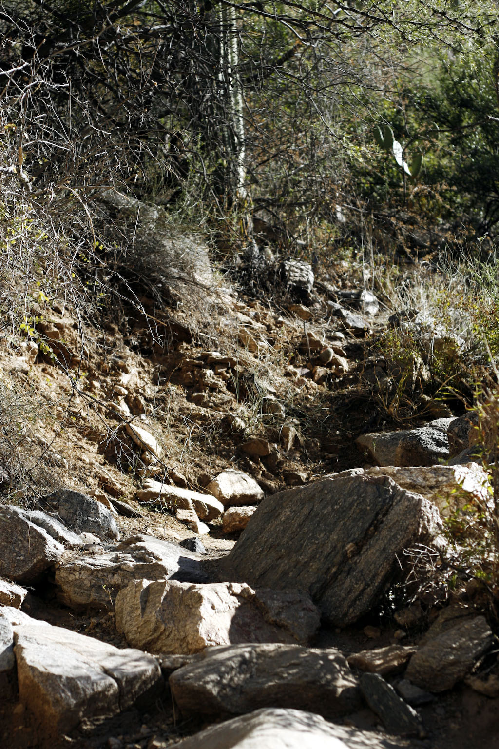
Pima Canyon Trail
 |
| Pima Canyon Trail Photo by David McErlean |
For my first hike back, I went to Pima Canyon Trail in the Santa Catalina Mountains.
Pima Canyon is an easy trail that starts on the west end of the Catalinas. The trail begins with a easy walk through the hills surrounded by local homes. On the trail, there are several areas that are great for picnicking with a large group. After the houses, the trail becomes covered in cotton wood trees. The trees shaded the trail, making it a great hike in the hotter months of the year.
After the first few miles, the trail becomes slightly steeper on the way to pima dam. The dam is a small rock wall with a thin layer of concrete over it. Hiking to the Pima Dam is an easy hike for every skill level.
Hiking to the dam is 3 to 4 hours round trip. Make sure to bring enough food and water. There is no fresh water anywhere on the trail. Some parts of the trail are not easy to see so follow the cairns that mark the trail.
For a longer hike, continuing on the trail after the dam will take you deep into the mountains to connect with Finger Rock trail to Mt. Kimball and further up Mt. Lemmon.
The first few miles of the trail are very popular on the weekends. Get to the parking lot early in the morning or later in the afternoon.
To get to the trail head, head north on N. Euclid Ave. Cross the Ina intersection and go into the neighborhood. Turn right on E. Magee Rd. The road will dead end in the parking lot.
Pima Canyon is an easy trail that starts on the west end of the Catalinas. The trail begins with a easy walk through the hills surrounded by local homes. On the trail, there are several areas that are great for picnicking with a large group. After the houses, the trail becomes covered in cotton wood trees. The trees shaded the trail, making it a great hike in the hotter months of the year.
After the first few miles, the trail becomes slightly steeper on the way to pima dam. The dam is a small rock wall with a thin layer of concrete over it. Hiking to the Pima Dam is an easy hike for every skill level.
 |
| Pima Damn Photo by David McErlean |
 |
| Cairn marks the trail Photo by David McErlean |
The first few miles of the trail are very popular on the weekends. Get to the parking lot early in the morning or later in the afternoon.
To get to the trail head, head north on N. Euclid Ave. Cross the Ina intersection and go into the neighborhood. Turn right on E. Magee Rd. The road will dead end in the parking lot.
View Pima Canyon Trail in a larger map
Sunday, February 20, 2011
Arizona Ghost Towns: Ruby Arizona
 |
| Ruby Arizona Photo by David McErlean |
Ruby is an old mining town that was abandoned in the 50's. Now, it is used as a tourist attraction with the historic town to search through, fishing and hiking.
 |
| School House in Ruby Ariz. Photo by David McErlean |
In the summer time, Ruby is home to thousands of bats living in the mine shaft. When the bats leave, it is said that they look like a cloud of smoke, flowing out of the tunnel for up to an hour.
The area is most popular for bird watching and fishing. The ponds hold trophy size bass and other game fish. The lake is quiet and you are almost guarantied to have it all to yourself. Ruby is open to the public Thursday through Sunday.
Things to remember: Make sure to fill you car with gas before getting onto the 289 from Nogales and bring food and water for the day; there isn't anything near Ruby. The road is dirt but maintained and patrolled often by U.S. Border Patrol.
 |
| Work Truck in Ruby Ariz. Photo by David McErlean |
View Larger Map
Sunday, February 13, 2011
Gone Walkabout: Gentleman Hiker's Arizona Trail Trek
Tune in Tuesday night at 7, MST for a live blog with Arizona's Gentleman Hiker, John Officer, to talk about hiking the Arizona Trail and tips to be more successful on the trail.
Sunday, February 6, 2011
Arizona Trail
 |
| Map from: Arizona Trail Association website |
"We all love the many features of the Arizona Trail. It has challenging mountains, pine forests, lush desert with towering saguaros and incredible canyons. Plus, there's the wildlife; from wild elk and javelina to colorful cardinals and red tailed hawks to scurrying gila monsters and, if you are very lucky, maybe a desert tortoise," said Dave Hicks, a hikers and the executive director for the Arizona Trail Association in a press release.
I plan to run start running segments of the trail this coming spring.
Saturday, February 5, 2011
Blue Gold: Wold Water Wars
 Water is the essence of life. Everything needs water to survive. Plants, animals, people, everything.
The blue gold is so vital to our survival that societies have gone through great lengths just for a taste of it. Societies have even worshiped it as a God.
The documentary, Blue Gold: World Water Wars, looks at the worlds water and the wars being fought for the control over its depleting supply.
Water in the U.S. is under appreciated. When a faucet is turned on, water is expect to come rushing out in endless supplies, but all that water has to come from somewhere. Soon, that somewhere is going to be no where. The water table world wide is getting lower. In some parts of the world, it is already gone.
About 70 percent of the earths surface is made up of water. Around 97 percent of the water is salt water. The rest is being stored in ice, rivers and underground waiting to be used. (U.S. Geological Survey)
Living in the desert, water is in high demand and low supply. Tucson has an increasing water shortage problem. The number of people living here is increasing while the amount of natural resources is plummeting.
The film takes an interesting look at what different societies have gone through to have clean drinkable water. It also looks at ways to stop the decline of the water table and start the recharge of drinkable water. Blue Gold: World Water Wars
Sunday, January 30, 2011
Buenos Aires National Wildlife Refuge
 |
| Buenos Aires NWR Photo by: David McErlean |
What was once used for camping, hiking, mountain biking, and hunting, is now an empty desert, patrolled by U.S. Border Patrol. The border war in the United States against illegal immigrants and drugs has made the area too dangerous for recreational use.
Named for the pleasant breeze that blows through the area, the Buenos Aires started in 1909 as a private ranch. U.S. Fish and Wildlife bought the ranch on August 1,1985 and established the Buenos Aires National Wildlife Refuge in Pima County, Ariz. to save the Masked Bobwhite Quail and other endangered wildlife, according to Congressional records.
 |
| Water Barrels in Buenos Aires NWR Photo by: David McErlean |
To help migrants from dying in the desert on their journey north, the Buenos Aires NWR has allowed Humane Borders to place water at three locations in the park. Marked by a blue flag raised 30 feet off the desert floor, two 55 gallon drums filled with drinking water wait for passing people in need of water.
In an effort to see how difficult water is to find in the desert, I went on a mission to find all of the listed water sources in the Buenos Aires. With the use of a map, compass, and a truck, I was able to find the listed water drums. The locations were full of water and in plain site, but the vastness of the desert landscape made me realize how next to impossible it would be to find the water after a day of running in the hot sun.
Read my story, A Quest for Water, for more information on the Humane Borders water tanks in the Ariz. desert at BorderBeat.
Vasque Wasatch GTX Hiking Boots
 |
| Vasque Wasatch GTX Photo by: David McErlean |
These boots are comfortable enough for every day footwear and rugged enough for the toughest of terrain.
I have gone through sand, mud, water and snow in mine and couldn't be happier. With every use they get more comfortable as they get more broken in.
The Gore-Tex fabric makes the boots fully water-proof but breathable to let the sweat out. Even trudging through snow for hours, the boots stay completely dry on the inside. The Vibram soles are durable and grippy on any terrain.
After multi-day trips with 10s of miles put in each day, these boots keep your feet comfortable and ready for the next day. I have hundreds of miles on my boots and they still yet to brake down. I highly recommend these boots for anyone that needs backpacking or hiking boots.
These three companies came together to make one great boot that hikers can enjoy around the world. Vasque Men's Wasatch GTX Hiking Boot,Moss Brown,12 N US
Finger Rock Trail, Tucson Arizona
 |
| Finger Rock Trailhead in Tucson Ariz. Photo by: David McErlean |
Finger Rock Trail starts at 3,100 feet and peaks at 7,255 feet of elevation. The 4,155 elevation climb is covered in five miles of hiking, ending on the summit of Mt. Kimball. Because of the fast climb, this trail is rated with the highest level of difficulty by the Arizona Sierra Club.
 |
| Start to Finger Rock Trail Photo by: David McErlean |
Tucson receives an average of six inches of rain a year with the majority of rain during the monsoon season. Monsoon season stars at the beginning of June and goes through September, according to RSS Weather.
Moving past the lavish homes built deep in the hills, the trail moves further into the canyon. Every step on the trail moves you deeper into the wilderness and away from the congestion of the city.
 |
| Switchbacks up to Mt. Kimball Photo by: David McErlean |
This is a great place to stop and take in the sights. Looking to the northwest you can see the famous finger staring from the adjacent peak. To the east is Mt. Kimball. Walking towards Mt. Kimball a half mile, there is a resting place over looking all of Southern Arizona.
If you are going for the summit, it's two more miles of steady climbing to the east.
I took the road less traveled and went for the Finger. Taking the trail that splits north, descend into the canyon that stands between the two peaks. Once at the river bottom take the trail straight up and point towards Finger Rock.
The trail to the finger can be difficult to see if it has not been used in a while. Be on the look out for cairns, neatly staked rocks used to mark trails, leading the way.
Once reaching the base of the rock formation, there is a rock climb to the the top. Overlooking a straight drop to the base of the mountain hundreds of feet below, climb the 30 foot rock face to the top. You might have to psych yourself up to let yourself climb to the top. Once reaching the top, the view is unparalleled by any other view in Tucson.
Taking the rarely used trail to the finger is more difficult than hiking to the summit of Mt. Kimball, but way more rewarding.
Plan on the hike taking six to seven hours. It is only six and a half miles round trip, but it is a lot of steep climbing. This hike is best during the fall, winter and spring months when it is cooler. Make sure to bring plenty of water and good hiking boots. Hiking poles will save your knees on the trek down from the summit.
For a more challenging hike to the top of Finger Rock, take the river to the top. The river path takes you up one waterfall after another. Make sure to bring rope incase you have to turn around and repel back down the waterfalls.
Directions to the trailhead from central tucson: Take N. Campball Ave. north towards La Encantada. Turn right on E. Skyline Dr. Stay on Skyline by making your first left. Then left on N. Alvernon Way, there are signs for Finger Rock Trail. The parking lot is on the left at the end of Alvernon. Map
If you are going for the summit, it's two more miles of steady climbing to the east.
I took the road less traveled and went for the Finger. Taking the trail that splits north, descend into the canyon that stands between the two peaks. Once at the river bottom take the trail straight up and point towards Finger Rock.
The trail to the finger can be difficult to see if it has not been used in a while. Be on the look out for cairns, neatly staked rocks used to mark trails, leading the way.
Once reaching the base of the rock formation, there is a rock climb to the the top. Overlooking a straight drop to the base of the mountain hundreds of feet below, climb the 30 foot rock face to the top. You might have to psych yourself up to let yourself climb to the top. Once reaching the top, the view is unparalleled by any other view in Tucson.
Taking the rarely used trail to the finger is more difficult than hiking to the summit of Mt. Kimball, but way more rewarding.
 |
| Finger Rock Trail Photo by: David McErlean |
For a more challenging hike to the top of Finger Rock, take the river to the top. The river path takes you up one waterfall after another. Make sure to bring rope incase you have to turn around and repel back down the waterfalls.
Directions to the trailhead from central tucson: Take N. Campball Ave. north towards La Encantada. Turn right on E. Skyline Dr. Stay on Skyline by making your first left. Then left on N. Alvernon Way, there are signs for Finger Rock Trail. The parking lot is on the left at the end of Alvernon. Map
Thursday, January 20, 2011
Welcome
Welcome to my blog. In my blog I will explore the Southwest and all that it naturally has to offer such as hiking, mountain biking, hunting and anything else that has to do with being outdoors. Along with showing the different places and things to do around the southwest region the United States, I will review different outdoor stores and products that will help you outfit yourself so you can get off the couch and share the same experiences. I hope it inspires you to go out and try new things.
Subscribe to:
Posts (Atom)